Click here to sign up for our free daily newsletter
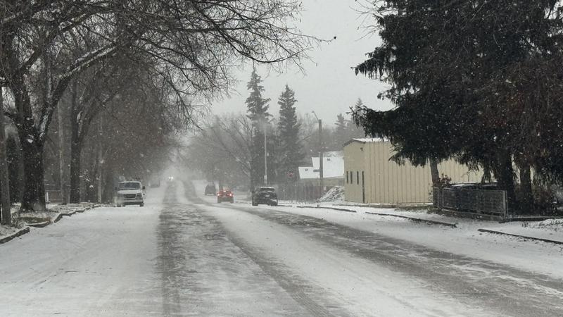
(File photo/battlefordsNOW)
BLIZZARD WARNING

Blizzard conditions grip Battlefords area as SaskPower crews stand ready

Dec 17, 2025 | 12:48 PM

Update: The City of North Battleford issued a Voyent Alert at 12:50 p.m., saying deteriorating weather has prompted a warning from the director of protective services, with roads inside the city reported as very icy and visibility reduced as of Wednesday afternoon.

Highway conditions in the area are described as similar, with visibility further worsened by high winds. “Further comment from the Director indicates that travel is not advised specifically due to the ice.

In the city, the reported visibility is not as bad as on the highway – which is said to be severely impacted – extreme caution is advised.”

Snow and strong winds will continue to affect the Battlefords today under a blizzard warning, but Environment Canada says conditions are expected to improve overnight as the system moves out of the region.

“It’s currently snowing and has been snowing for a while. The winds are starting to pick up,” said Terri Lang, a meteorologist with Environment and Climate Change Canada.

Lang said the Battlefords are on the northern edge of the storm, with snowfall totals lower than farther south, but winds will be the main issue this afternoon.

“Those winds starting to come up probably the strongest this afternoon with wind gusts as high as 60 to 70 kilometres per hour,” she said. “So blowing and drifting snow is quite likely.”

The system is expected to move out overnight.

“Snow should ease off, the winds should diminish, and you’ll just be into some cold air by tomorrow morning,” Lang said.

Environment Canada is also tracking a risk of freezing rain Wednesday in parts of southern Saskatchewan, stretching from Leader and Kindersley through Swift Current, Moose Jaw, Regina, Estevan and Broadview.

Another system is expected to move through on Friday, bringing lighter snowfall of about three to five centimetres and less wind than today, though it could still affect travel.

SaskPower is ready

As the storm moves through, SaskPower says crews are ready in case strong winds lead to power outages.

“There might be some power outages as a result of the high winds that are forecasted,” said Scott McGregor, a SaskPower spokesperson.

“To prepare, we do have our crews ready to respond to any outages across the province,” he said.

McGregor said response times could be longer during periods of blowing snow and reduced visibility, as crews may need to wait until conditions are safe.

SaskPower is also urging residents to stay well back from downed lines.

“There’s no way of knowing if that line is still energized,” McGregor said, adding people should stay at least 10 metres away and call 911 in an emergency or SaskPower’s outage centre at 310-2220.

Environment Canada says this is the strongest system the region has seen so far this season, with travel expected to be the most impacted and advising people to avoid unnecessary travel as conditions continue to deteriorate.

“The best thing to do if you can is to hunker down and just stay put,” Lang said. “If you don’t need to travel, don’t travel.”

Lang said anyone who must travel should check the Highway Hotline before leaving and make sure they are prepared for winter driving, including snow tires, an emergency kit, a charged phone and a full tank of gas.

As of publication, highways surrounding the Battlefords are mostly covered in slow. Conditions are expected to deteriorate as the weather progresses throughout the day, and motorists are urged to closely monitor updates before heading out.

As of publication, highways surrounding the Battlefords are mostly covered in snow and marked in yellow on the highway hotline map. (screenshot)

Kenneth.Cheung@pattisonmedia.com