Sign up for the battlefordsNOW newsletter

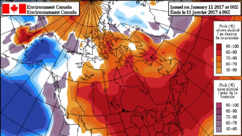
Saskatchewan to warm up significantly over the weekend

Jan 12, 2017 | 5:00 AM

The rollercoaster ride that is Canadian weather will begin a substantial incline this weekend in Northern Saskatchewan.

After temperatures well below average started off the first half of January, Environment Canada is calling for the last two weeks to be well above average.

While today will still have wind chills reaching -40 Celsius, temperatures will start to warm up Friday and by Monday, many areas of the province will see a high of 0 Celsius.

John Paul Cragg, a warning preparedness meteorologist with Environment Canada, said the extreme change in temperatures isn’t exactly uncommon in the Prairies.

“Often we don’t see temperatures that are considered average for this time of year,” Cragg said. “What we are seeing is a big fluctuation because of the two air masses infiltrating the province. Either we get that cold arctic air, or that warm pacific air and rarely do we get the in between where we are sitting at average temperatures for long periods of time.”

Cragg said the reason the Prairies see such extremes is simply due to geography. Because there are no mountains, or any barrier, between Saskatchewan and the North West Territories, it allows arctic air to stream right into the province. Cragg added because it is a short distance for air to travel it has no time to warm up, so we see below average temperatures like the first two weeks of January.

On the flip side, Cragg said when the winds start coming in from the west, the mountains help warm up the air as it goes over the Rockies. Cragg added it is similar to a Chinook.

“A Chinook is a very specific event that happens on leeside of the mountains but you are seeing a very similar effect,” Cragg said. “What you are seeing is down slope flow. As air descends from higher in the atmosphere it actually warms up.”

Cragg explained the air continues to descend all the way from Alberta and into Saskatchewan. He added even though the cold ground frozen by sub -30 C temperatures, tries to cool the air, the continuous dissention of the air counteracts the effect.

Cragg said due to these two air masses, January had an average high of -10 C and a low of -21 C but very rarely are those the actual temperatures experienced. According to Cragg, after it’s all said and done, January will end up hitting the average, even though the first two weeks were unseasonably low and the last two will be unseasonably high.

Cragg said the unseasonably high temperatures coming, though pleasant in the day, bring certain dangers. 

“When you get temperatures hovering around the 0 Celsius mark, it can make for very slippery road ways,” Cragg said. “You can get frost on the roads. The ground is still cold but the sun warms the pavement … it might melt the ice or precipitation on the road and then the overnight temperatures quickly freeze that.”

Cragg added the road conditions caused by the warmer temperatures aren’t much different than the ones caused by extreme cold. The meteorologist added at -30 C salt won’t melt ice built up on the roads, so conditions can be just as dangerous.


Greg Higgins is a battlefordsNOW’s reporter. He can be reached at ghiggins@jpbg.ca or tweet him @realgreghiggins.